Photo Adventures with Curiosity and Learning
Tiep has added GPS data to our oximeter app (http://port.duke-nus.edu.sg/sms) developed by Hirwan and Kaung. This morning's jog was a proof of concept test of the gps data derived from the oximeter app (android) reporting real time HR and %O2 Sat. The track is quite course because I only sent oximeter data (via SMS every few minutes. Maybe tomorrow I'll send more frequent data now that we have a proof of concept
Here is the consolidated map - just hover over the cyan direction arrows to see accumulated distance and over the red stick pins to see my data
To get to the above consolidated map, I made a results map - Here are the Oximeter results - click on each stick pin to see HR and % O2 Sat
And a jogging track map. Arrows indicate direction of jogging and the distance between arrows is 250 m. Hover over the directional arrows to see the cumulative distance. Total path is about 3 km.
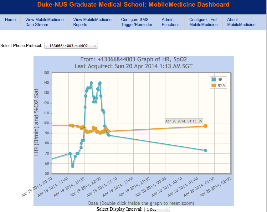
Here is a graph of the raw oximeter data
An early morning jog around the lake followed by a photo shoot. A flock of white ibises

White Ibis

Six ducks diving

Hungry ducks

Mom barred owl. Having watched the mom, dad and little ones for several weeks - it seems to me that flying is a reflex to maintain balance. I've watched the little on - having not apparently ever flown - but hopped with wing assisted hopping from the nest to a limb near mom. This required traversing several limbs and trees. Each time she/he loses balance, her wings go into action - great practice for flying. But what is flying? I now think its nothing more than maintaining balance in the air - just as he/she maintains balance on a tree limb.

The little barred owl - mostly a fluff ball

Back to the ducks


This work is licensed under a Creative Commons License.
C. Frank Starmer